Recent searches
Search options

Administered by:

#bcstorm


 ️
️ 


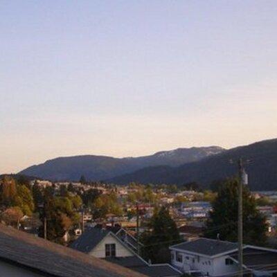
Oh now that is a satellite picture to get excited about! #bcstorm
Had a good bunch there including a few in/over town.
Line is moving across the Island north south. #bcstorm

It's here! Lightning over Arrowsmith! #bcstorm Lots!!
New article: Severe t-storms possible in Pacific Northwest Wednesday
- Risk of hail larger than limes near #Seattle and #Portland
- Isolated #tornado possible
- Scattered t-storms throughout the region
https://ingallswx.com/2025/03/25/severe-t-storms-possible-in-pacific-northwest-wednesday/


Wind warnings issued for the east and west coasts of the Island plus Victoria. North Coast and Inland not currently included.
Ferry Cancellations possible.
https://weather.gc.ca/index_e.html?layers=alert¢er=48.36939836,-125.84974155&zoom=6

New article: Cold week ahead with widespread snow for Pacific Northwest
https://ingallswx.com/2025/02/03/cold-week-ahead-with-widespread-snow-for-pacific-northwest/


Morning #SocialBC folks! 
If you would like to follow some fun and useful hashtags, just click below. It’ll help fill your timeline and get you acquainted with some of the quirky tendencies of Mastodon.
BC Specific:
#bcpoli
#bcstorm
#bcmuni
#SocialBC
General fun:
#introduction
#firstpost
#monsterdon
#bloomscrolling
#mosstodon
#hnom
#pollodon
#fediverse
#allstartrek
Day specific
#mondog
#tuesdog #tuesdaytoolsday
#wellnesswednesday
#thicktrunkthursday
#fensterfreitag
#caturday
#SilentSunday
#Vancouver #weather
20241230
Rain showers through Wednesday, mainly near the mountains. Sunbreaks likely in places like Surrey and Langley. Trending cooler from a high of 8 today to a high of 5 Wednesday. More rain in the days beyond.


Another wind storm, #bcferries canceled most of the day and random power outages.
Turbulent waves covered the rocks with sea foam.

#Vancouver #weather
20241217
Heavy rain is forecast to begin today with wind picking up as well. By tomorrow morning areas like Coquitlam and North Van could have 100 mm of new rainfall.
Showers tomorrow and Thursday, more action as we head into the weekend.
Looking like a highly impactful system is possible around Christmas with strong wind, heavy rain, and heavy mountain snow.
New article: High pressure keeping widespread fog and low clouds in Pacific Northwest lowlands
Discussion and analysis of the #weather pattern, including an in-depth look at data used in observing the inversion.
Watch for freezing fog in Whatcom County and the Lower Mainland this morning. The temperature inversion remains strong thanks to high pressure overhead.

#Vancouver #weather
20241202
Periods of clouds and sun and chilly as an upper level ridge traps cold air down in the low elevations through Wednesday. The next system rolls in Wednesday night followed by another Friday afternoon for rain showers during the second half of the week.
Some sunbreaks in Ucluelet this morning. The sea lions were jumping around a bit this morning.
