For this week’s #throwbackthursday, here are The Lands of Zimara, a map commission from a few years ago.


For this week’s #throwbackthursday, here are The Lands of Zimara, a map commission from a few years ago.
I just had an email from Gabe Moss at the Ancient World Mapping Center at UNC Chapel Hill alerting me to "the release of Livy Study Maps: Book 22, the latest addition to the Maps for Texts series."
More here: https://awmc.unc.edu/2025/03/20/livy-study-maps-book-22/
"... this set of twenty-three maps is designed for students and teachers working with Livy’s text, and offers detailed coverage of famous episodes such as the Battles of Lake Trasimene and Cannae, as well as of lesser-known campaigns from Book 22 of the History of Rome. The maps are available as free digital downloads under the CC-BY-NC 4.0 license."
One day, one map
Far from the reality of state control
#Migrations #Cartography #Walls #Deaths #Camps #Borders
Source: Migreurop, 2022

At the beginning of the year, the Federal Office of Topography published the swissTNE Base, which summarises all transport routes (rail, road, cable and water).
Having this data, you can't avoid the temptation to recreate @benfry beautiful 2010 work All Streets

Across half the Pacific to Hawaii…the #Petrofuture maps. 66m sea level rise — melted ice caps on a vintage Chevron gas station map. Higher-res images: https://conspiracyofcartographers.com #climateChange #maps #cartography #climateCrisis #greenWashing #Hawaii #Kauai #Maui #worldBuilding #Oahu #Molokai #HawaiianIslands #Chevron

Next up is South America…the #Petrofuture —
Melted ice caps on a vintage Esso gas station map.
Higher-res images:
https://conspiracyofcartographers.com
#climateChange #maps #cartography #climateCrisis #greenWashing #SouthAmerica #Brazil #Brasil #worldBuilding #Argentina #Colombia #Venezuela #AmazonRiver #Chile #Peru #Ecuador #Paraguay

A quick illustrative #map on the implications of using different types of centroids in regional #demography #mobility and #migration studies.
Think about what you are emphasizing.
By using population-weighted centroids, you can emphasize the population perspective in the analysis instead of the geometry, potentially improving your analysis considerably. The distance difference is stronger in sparsely populated and remote regions.

Pobre México, tan lejos de Dios y tan cerca de Estados Unidos. #Petrofuture Mexico — 66m sea level rise on a 1956 Shell gas station map.
Higher-res images:
https://conspiracyofcartographers.com

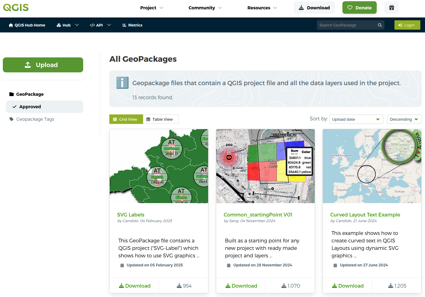
Did you know that you can package a complete #QGIS  project (incl. all your layers and data) in a single #Geopackage file, e.g. to move it to another system?
Practical examples, on the new hub:
https://hub.qgis.org/geopackages/?sort=upload_date&order=desc
Mississippi flooding…US states along the Gulf of Mexico—In #Petrofuture form—Melted ice caps on a 1956 Shell Oil road map. Higher-res images: https://conspiracyofcartographers.com #climateChange #maps #cartography #climateCrisis #greenWashing #Alabama #Texas #worldBuilding #gulfOfMexico #Louisiana #Mississippi #MississippiRiver #Arkansas #MemphisTN

Lately, I've been messing around with adding modern 3D elevation relief to historic maps. This is the original GLO survey from 1859-60 of the Grand Marais, Minnesota area.
Learning how to do this has been challenging. I've been using QGIS > Photoshop > Blender > Photoshop as the workflow.

Climate change will mess with Texas.
The #Petrofuture map—Melted ice caps on a 1956 Shell Oil road map.
Higher-res images:
https://conspiracyofcartographers.com
#climateChange #maps #cartography #climateCrisis #greenWashing #BrownsvilleTX #permianBasin #Texas #CorpusChristi #worldBuilding #gulfOfMexico #Houston #Galveston

How are your gaming opportunities looking for the weekend? Are you dwelling deeper into a long running campaign, or will you be charting new adventures?

'Gallus Glasgow'
Wonderful old map of Glasgow from the 1860s with interactive data layers on old and new buildings.
Love to see how the city developed over the last 150 years.
One of my favorite #Petrofuture maps….The Mississippi River becomes a vast inland sea reaching up to Memphis.
Of course New Orleans is gone. I mean, c’mon.
Melted ice caps on a 1956 Shell Oil road map.
Higher-res images:
https://conspiracyofcartographers.com
#climateChange #maps #cartography #climateCrisis #greenWashing #Louisiana #Mississippi #NewOrleans #worldBuilding #gulfOfMexico #MississippiRiver #Memphis

Something is brewing at The Voyager’s Workshop! Progress on the development of the Guildenhof Town Guide is going well. Still lots more designing, writing, editing and illustrating to do, all by yours truly!


The Concept Of Indigenous GIS
--
Reading a paper (http://alturl.com/8wte5), they used the specific term ‘Indigenous GIS’ – and I found this intriguing!
As I read it, spatial data collection and analysis was done with a focus on how a tribe or social group might ‘see’ the data, including spatiotemporal....
I look forward to finding out more about what others are working on! – so PLEASE feel free to share any examples that you might have…
#GIS #spatial #mapping #indigenous #IndigineousGIS #FirstNation #perspective #cultural #social #naturalresources #archaeology #publicsafety #socialservices #planning #design #spatialanalysis #spatiotemporal #mapping #cartography #usecase #practical #pragamatic #resultsdriven #focused##


Six inches forward and five inches back, the #Petrofuture Florida map is one of the more dramatic ones. 66m sea level rise will emasculate the state.
Melted ice caps on a 1956 Shell Oil road map.
Higher-res images:
https://conspiracyofcartographers.com/petrofuturegallery/
#climateChange #maps #cartography #climateCrisis #outsiderArt #solarPunk #steamPunk #greenWashing #Florida #worldBuilding

A #TikTok #handdrawn #map #video! This time it’s all 3 maps of the deserted outpost & mine 

Georgia is on my mind, and it's also the next up in the #Petrofuture series.
And look--Georgia contains Florida's angry inch!
Melted ice caps on 1956 Shell Oil road map.
Higher-res images:
https://conspiracyofcartographers.com/petrofuturegallery/